


 The Government Circuit: Driving Resiliency and Economic Security on Both Sides of the Atlantic
 American Made Advocacy: Taking the Fight to Capitol Hill
 Defense Speak Interpreted: SWaPing Nanosatellites for Defense Systems
Satellite Sensors Would Deliver Global Fire Coverage
November 26, 2015 | NASAEstimated reading time: 2 minutes
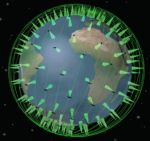
Wildfires can wreak havoc on human health, property and communities, so it's imperative to detect them as early as possible. That's why NASA's Jet Propulsion Laboratory, Pasadena, California, is working on a concept for a network of space-based sensors called FireSat in collaboration with Quadra Pi R2E, San Francisco.
FireSat would be a constellation of more than 200 thermal infrared imaging sensors on satellites designed to quickly locate wildfires around the globe. Once operational, FireSat would represent the most complete monitoring coverage of wildfires ever from space.
"While many wildfires are reported by 9-1-1 calls soon after ignition, some are not, and delays in detection can lead to rapid escalation of a fire, and dramatic growth of the cost of suppression. The system we envision will work day and night for fires anywhere in the world," said Robert Staehle, lead designer of FireSat at JPL.
The FireSat sensors would be able to detect fires that are at least 35 to 50 feet (10 to 15 meters) wide, within an average of 15 minutes from the time they begin. Within three minutes of detecting a fire from orbit, FireSat would notify emergency responders in the area of the fire, improving support for time-critical response decisions.
The sensors and their associated products for data analysis would also be able to locate explosions, oil spills and other dangerous events involving high heat around the globe.
Staehle's team first presented the concept of FireSat in 2011 to the joint NASA/U.S. Forest Service Tactical Fire Remote Sensing Advisory Committee. The team has spent the subsequent years refining their understanding of fire monitoring needs and technological requirements.
"Such a system has only now become feasible at a reasonable cost, enabled by advances in commercial microelectronics that NASA, JPL and universities have tested in space via CubeSat experiments, and by software technology originally developed to give Mars rovers and Earth orbiters more autonomy in their science observations," Staehle said.
FireSat sensors would complement the fire monitoring done by NASA satellites and systems already in place. For example, the Terra satellite has an instrument called MODIS (Moderate-resolution Imaging Spectroradiometer) that contributes to fire detection. The Sensor Web Project uses a network of sensors in conjunction with autonomous satellite observation to study wildfires, volcanoes, flooding and events related to ice freezing and thawing. Earlier in 2015, maps of fires were made using data from instruments that include JPL's Airborne Visible/Infrared Imaging Spectrometer (AVIRIS), JPL's MODIS/ASTER Airborne Simulator (MASTER), and lidar data. FireSat's envisioned software for fire detection would inherit aspects of JPL's Autonomous Exploration for Gathering Increased Science (AEGIS) software.
While existing satellite-based fire-searching sensors can only detect fires about twice a day, and transmit large images, FireSat would be able to send a low-resolution image of a fire once per minute, along with the latitude and longitude of exactly what is burning. This would enable faster, nearly continuous communication with the ground.
JPL will assist in the design, demonstration and development of the proposed sensor constellation. Ecliptic Enterprises Corp., Pasadena, California, will serve as the production supplier for the sensor assemblies.
"We'll complete sensor integration and testing in batches and deliver them on a regular pace to the host spacecraft series starting in 2017," said Rex Ridenoure, CEO of Ecliptic.
The current plan is to have a fully operational system of FireSat sensors in space by June of 2018.
"The environmental justification is without question, and its realization makes incredible economic and security sense," said Arthur Lane, Quadra's technical coordinator for FireSat.
The California Institute of Technology manages JPL for NASA.
Share on:


Suggested Items
Inkjet Solder Mask ‘Has Arrived’
04/10/2024 | Pete Starkey, I-Connect007I was delighted to be invited to attend an interactive webinar entitled “Solder Mask Coating Made Easy with Additive Manufacturing,” hosted by SUSS MicroTec Netherlands in Eindhoven. The webinar was introduced and moderated by André Bodegom, managing director at Adeon Technologies, and the speakers were Mariana Van Dam, senior product manager PCB imaging solutions at AGFA in Belgium; Ashley Steers, sales manager at Electra Polymers in the UK; and Dr. Luca Gautero, product manager at SUSS MicroTec Netherlands.
NetVia Group Acquires Direct Imaging from Mivatek
04/09/2024 | Miva TechnologiesMiva Technologies is pleased to announce NetVia Group, Irving, TX has acquired a new Miva 2400NG Dual Tray Direct Imaging System with 30-micron capabilities for inner, outer and soldermask imaging.
Teledyne to Acquire Adimec
02/13/2024 | TeledyneTeledyne Technologies Incorporated announced that it has entered into an agreement to acquire Adimec Holding B.V. and its subsidiaries.
Real Time with... productronica 2023: MivaTek Global Advances Technology With High-res Imaging System
12/08/2023 | Real Time with...productronicaMivaTek's Brendan Hogan talks about how the company employs Digitally Adaptive Rasterization Technology (DART) in their high-res imaging equipment. He also shares how the blurred line between semiconductors and microelectronics is driving broader application of the imaging process.
Keysight Enables Validation of Arbe 4D Imaging Radar Chipset
11/30/2023 | Keysight Technologies, Inc.Keysight Technologies, Inc. announces that Arbe has selected the E8719A Radar Target Solution (RTS) to test the Arbe 4D imaging radar chipset for automotive applications.