


 The Government Circuit: Driving Resiliency and Economic Security on Both Sides of the Atlantic
 American Made Advocacy: Taking the Fight to Capitol Hill
 Defense Speak Interpreted: SWaPing Nanosatellites for Defense Systems
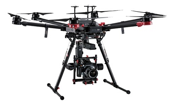
Drone Technology Benefits Society
August 21, 2017 | DTUEstimated reading time: 4 minutes
According to the Danish Drone Strategy, the Danish Government wants to promote the use of drones in the public sector. And now a string of DTU projects have become airborne.
Common mussels, eelgrass and mines left in the sea as wartime relics are just some of the things that drones can be sent in search of as part of DTU projects.
In other words, DTU is busy realizing the objectives of the Danish Government’s new Danish Drone Strategy—that the use of drones should be promoted for solving important tasks within the public sector.
“The strategy promotes the use of drones, and ties in well with the expertise we’ve built up at DTU in recent years,” says Senior Executive Officer Michael Linden-Vørnle, DTU Space. He heads DTU Space DroneCenter, which was established in autumn 2014.
DTU Space researchers are involved in all the centre’s projects, as well as researchers from a number of other departments.
“Getting a piece of hardware airborne today is child’s play. The exciting challenges lie in combining drone technology with other technologies. Here, DTU in particular is able to make a real contribution,” says Michael Linden-Vørnle.
In the Wadden Sea, the Danish Shellfish Centre at DTU Aqua is coordinating a project where drones identify three species of shellfish: mussels, cockles, and Pacific oysters. The Danish part of the Wadden Sea is a national park, and is also protected by EU legislation. Therefore, no extensive shellfish fishing has taken place in the Wadden Sea in recent years.
“However, we don’t actually know whether it would be sustainable to permit fishing for mussels and oysters as the populations haven’t been estimated for the past ten years,” says Pernille Nielsen, a researcher at DTU Aqua.
Previously, aerial photography was used in conjunction with expeditions on foot to estimate shellfish population sizes in the Wadden Sea. Aerial photography can cover a large area, but the resolution of the images is usually too poor to determine whether they are actually shellfish you are looking at. In addition, aerial photographs only provide information on the positions of mussels, and not the size of the populations. Drones on the other hand can help cover a very large area, while estimating the size of the populations more precisely.
Another DTU project involves the development of a long-distance drone with vertical take-off and landing capability at sea. Here, researchers from DTU Space and DTU Environment have developed the Smart UAV (Unmanned Aerial Vehicle—the technical term for a flying drone) in collaboration with the north Jutland-based company Sky-Watch.
“The Smart UAV is a dream tool for students and researchers because it is so flexible. Depending on requirements, it can be configured to test many different proof-of-concept applications,” says Jakob Jakobsen, a researcher at DTU Space.
In addition to the drone, a number of instrument packages have been developed for the project. For example, the Smart UAV can be used for the common mussel and eelgrass projects. Or it can be used for other types of environmental monitoring, for establishing a river’s long profile, or for deploying in rescue missions at sea,” explains Jakob Jakobsen.
“You can also launch the drone from a freight ship when sailing in waters where there is a risk of icebergs, or it can be launched to spot pirates’ vessels from a safe distance.”
In Horsens Fjord and in the Little Belt, the Danish Shellfish Centre is carrying out a project in collaboration with the DTU Space DroneCenter. Here, they are testing whether drones can map the populations of common mussels located in deeper water. In contrast to the Wadden Sea, the mussels in Horsens Fjord and the Little Belt are not exposed at low tide. The main purpose of the project is to develop methods for mapping eelgrass using drones.
“This is because eelgrass is an important indicator regarding the health of marine ecosystems. With drones, it is possible to fly over well-defined areas and revisit exactly the same areas year after year. Flying drones is also cheaper compared to aerial photography, which is also a less accurate method,” says Pernille Nielsen.
The project was initiated in 2016, and runs for two years. The majority of the drone flights will take place in 2017.
Most recently, Senior Researcher Arne Døssing, DTU Space, received financing from Innovation Fund Denmark for a project to develop a special version of the Smart UAV for locating unexploded mines. There are still believed to be more than 10,000 mines from World War II in the sea and on land in Denmark. The new drone will be equipped with magnetometers, and will be able to spot the mines given that their magnetic profile is clearly distinct from that of their surroundings. The project is being conducted in cooperation with Sky-Watch A/S, Geo, DONG Energy as well as Danish Defence.
“The Smart UAV is a very good example of a concept that holds considerable scope for development. The list of possible applications will definitely continue to grow,” says Michael Linden-Vørnle, who adds that the drone research at DTU should be seen in a larger perspective:
“It’s not just about individual drones and systems such as the Smart UAV. We want to focus on how autonomous drones in all domains—on land, at sea, and in the air—can supplement and complement our existing infrastructure.”
Share on:


Suggested Items
Groundbreaking Ceremony Marks the Beginning of a New Era for Newccess Industrial; The Construction of the MINGXIN Building
04/12/2024 | Newccess IndustrialOn a clear and sunny day in March, the groundbreaking ceremony for the MINGXIN Building took place in Shenzhen, China. This moment marked the official commencement of construction for a project that will reshape the semiconductor materials industry.
Sondrel Poised to Support the Evolution of Intelligent Cars with Ultra-Complex Chips
04/08/2024 | SondrelAccording to Sondrel, a leading provider of ultra-complex chips, the designing of Software Defined Vehicles (SDVs) is changing the automotive ecosystem, including new methodologies and technology approaches that could significantly reduce costs and shorten time to market for advanced features.
Creators of SMT UHDI Test Board Vehicle Discuss this Important Project
04/04/2024 | Nolan Johnson, I-Connect007Chrys Shea of Shea Engineering and Altium’s David Haboud educate us on the latest revision of the SMT test board for UHDI testing, presented at the SMTA UHDI Symposium on March 26 in Arizona. Chrys was involved in the original SMT test board, introduced roughly five years ago. She and David discuss recreating the test board to be appropriate for UHDI, the genesis and history of this project, and why industry members should make use of it to benchmark their processes.
Smartkem Commences Project with RiTdisplay
03/22/2024 | PRNewswireSmartkem, the developer of a disruptive type of organic transistor that has the potential to drive a new generation of displays, today announced that it has entered into a collaboration agreement with RiTdisplay Corp. (RiTdisplay), a leading developer of optoelectronic solutions, visual displays and passive-matrix OLED (PMOLED) displays, for the manufacture of a new type of active-matrix OLED (AMOLED) display.
SIA Applauds CHIPS Act Incentives for Intel Projects
03/20/2024 | SIAThe Semiconductor Industry Association (SIA) released the following statement from SIA President and CEO John Neuffer commending semiconductor manufacturing incentives announced by the U.S. Department of Commerce and Intel Corporation.